
Updated at 10:30 a.m. Thursday to reflect the current forecast and conditions.
North Texas woke up to heavy rain and some areas saw flooding. By 7:15 a.m., 4 inches of rain had fallen in some areas.
While rain could continue throughout the day into the overnight hours, the best chance for widespread rain will come during the day Friday, when an area of low pressure moves north of the area and a trailing cold front sweeps through from west to east.
Overnight showers and thunderstorms were triggered by cold front arrived in Dallas-Fort Worth on Wednesday, along with the moisture in place.
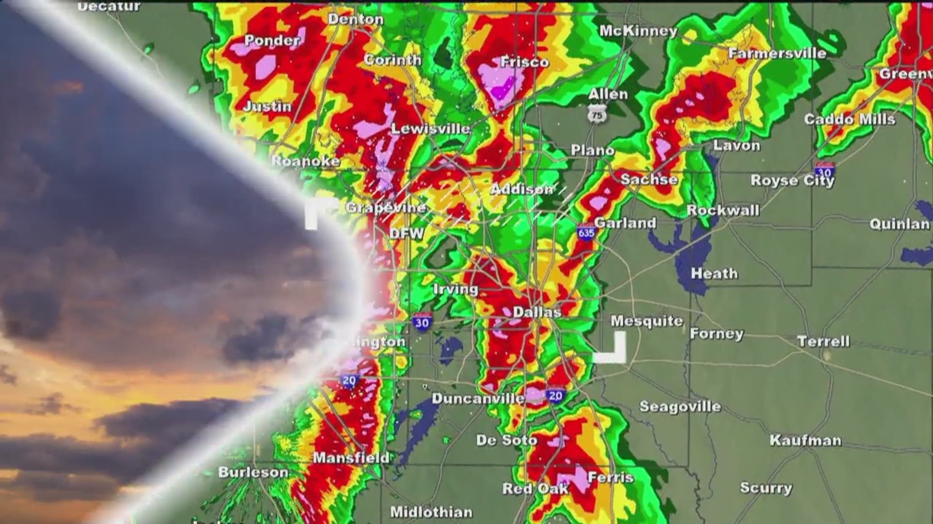
Widespread showers with embedded storms moved through the area Thursday morning. While the severe weather threat is low, heavy rain caused some flash flooding in some areas.
A flash flood warning was in effect through 10 a.m. in Tarrant County. It had been extended from its original timeline, which was 8 a.m. A flood advisory was issued until 9:15 a.m. in Dallas County.
Nearly 2 inches of rain had already fallen in some areas by 6:15 a.m. By 7:15 a.m., that count had increased to 4 inches in some areas.
Possible flooding
The National Weather Service warns that an additional 1 to 2 inches of rainfall is expected Thursday morning for Dallas County and that excessive runoff from the storms could create urban and small stream flooding.
NWS has also put a flood warning in place for the Trinity River in Dallas. The warning is expected to begin around 3:30 p.m. Thursday and last through Saturday due to high waters.
The stage was above 24.5 feet by 7 a.m., according to the NWS, and is expected to rise to a crest of 32 feet by Thursday afternoon as runoff builds throughout the day. The flood stage is 30 feet for the river.
Expect the rain to continue through the morning commute and be prepared for possible high waters on the roadways. Ponding could be possible as well, so be careful of hydroplaning.
Road Conditions
Dallas Fire-Rescue had responded to at least four water rescue calls by 8 a.m. Thursday morning, all of which involved vehicles getting stuck in high water and occupants walking to safety, a spokesperson told WFAA.
There were at least 37 different accidents in Dallas between 5 and 8 a.m. as well, the spokesperson said.
A loaded school bus slid off the road in Fort Worth around 7:30 a.m. and got stuck in mud, a MedStar spokesperson said. No one was injured in the incident.
From 5 a.m. until 8 a.m., Fort Worth had a total of 15 minor accidents and nine major accidents, a police spokesperson confirmed.
Multiple streets in Fort Worth were also experiencing high water. Officials were asking drivers to find different routes Thursday morning to avoid the roadways altogether.
Remember: Drive at a safe speed for road conditions and turn around, don't drown.
Cooler weather
The front is expected to stall out across part of the area, which will trigger more showers and thunderstorms into the day Thursday.
Depending on how far south the front gets before stalling will determine placement for the best rain chances on Thursday and what D-FW temperatures will be.
Places north of the front will struggle to get out of the 40s. In the south, temperatures will remain in the 60s.
As the area of low pressure pushes northeast into the area, the stalled front will lift north as a warm front. This will push most of the moisture north and west. So, the best chance of rain on Thursday night and Friday morning will be north of Interstate 20 and west of Interstate 35.
This will also put most of North Texas in the warm sector and temperatures during the afternoon will be once again above average.
During the day Friday, the area of low pressure will move north of the area and a trailing cold front will sweep through here from west to east.
This will bring the rain back south and all of North Texas will be under the gun for widespread rain. There may be a few embedded thunderstorms, but severe weather is not expected.
The front will move east of us by Saturday morning and we will see clearing skies from northwest to southeast during the day Saturday.