The National Weather Service is investigating four possible tornadoes that tore across North Texas Sunday, injuring dozens and killing at least two people.
From noon Friday to midnight Sunday, there were 197 weather-related warnings given to residents. Forty-six of those were Tornado Warnings, 44 were Flash Flood Warnings and 107 were Severe Weather Warnings.
The National Weather Service is estimating that at least four tornadoes touched down Sunday in Van Zandt, Denton, Grayson and Hamilton/Bosque Counties. Kaufman County damage is also under investigation.
More than 43 people were injured in the Van Zandt storm. Two people were confirmed dead Monday morning in Van, and eight are still unaccounted for. A Tornado Warning was issued for Van Zandt County until 9:30 p.m. after the area briefly saw all Tornado Warnings canceled.
Corsicana reported several high water rescues overnight, and one confirmed fatality.
Ellis, Henderson, Kaufman, Navarro and Van Zandt Counties were under a Severe Thunderstorm Watch until 10:15 p.m.
Parts of North Texas remained under a Tornado Watch until 11 p.m. That watch was scaled back and did not include Dallas and Tarrant Counties.
The drenching rains have been kind to area lakes, with several lakes up a considerable amount after this weekend.
Tornado Warnings for Navarro and Ellis Counties expired at 8 p.m. Several other counties were under Tornado Warnings that expired at 7:30 p.m.
WEATHER ALERTS: Check the latest warnings, watches and statements
 North Texans were bracing for yet another round of stormy weather Sunday night after a morning and afternoon filled with heavy rain, flash flooding and tornado sightings.
A confirmed tornado was reported in Kaufman County near Cottonwood shortly after 6 p.m. Residents of Scurry, Oak Grove and Grays Prairie were advised to seek shelter immediately.
Just south of Haslet near U.S. 287, BNSF Railway officials reported, high winds shortly before 7 a.m. Sunday knocked over 38 empty containers on rail cars, the Star-Telegram reported. The train was headed from the Alliance area in north Fort Worth to Oakland, Calif.
Officials did not have an estimate of when the tracks would be cleared. At 5 p.m. Sunday, workers were still there.A Tornado Warning for Grayson County expired at 4:30 p.m.
At 3:37 p.m., a severe thunderstorm capable of producing a tornado was located near Sherman, moving northeast at 15 mph. Sherman could be in the path of a tornado.
At 3:25 p.m., Grayson County Emergency Management said a funnel cloud was confirmed in Gunter, tracking northeast at 40 mph.
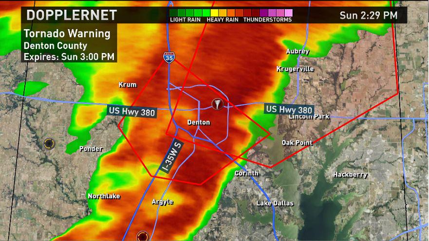
A Tornado Warning for Denton County expired at 3 p.m. Sunday. There were confirmed reports of a tornado touching down near the city of Denton.
The funnel cloud may have been invisible to many people because it was wrapped in rain.
Reporter Todd Unger witnessed trees down, utility poles bent over, and the increasing threat of flash flooding in Cross Roads, just east of Denton.
Aerial views from the south side of Denton showed the roof of one business at Boyd Center on Highway 377 had been peeled away by high winds. The Kayaking Mediterranean Restaurant also lost its roof in the storm.
There was evidence of additional damage in the Bent Creek Estates residential neighborhood less than three miles southwest of Golden Triangle Mall. There, trees and fences were toppled and some roofs appeared to be damaged.
Denton police spokesman Ryan Grelle said damage in the city was primarily limited to falling trees, and that no injuries were reported.
HD RADAR: Denton County
At 2:42 p.m., the circulation was located near Krugerville moving toward Celina.
Jamie Woodward posted video that may represent the formation of the tornado in Northlake.
There is a Tornado Watch for all of North Texas until 9 p.m.
Very heavy rain triggered localized flash flooding. The weather service issued a Flash Flood Warning for Denton and Cooke counties until 7:15 p.m.; for Wise County until 5:45 p.m.; and for Dallas, Collin, Ellis, Grayson and Fannin counties until 2 p.m.
"Flooding of some extent is reported in every county around Dallas/Fort Worth," WFAA Chief Meteorologist Pete Delkus said. That's because 48-hour rainfall totals in many areas exceeds one inch.
Granbury has received 4.8 inches over two days; 3.1 inches has accumulated in Decatur, and Bridgeport has received 2.3 inches.
This dramatic video along Turtle Creek in Dallas illustrates the heavy runoff:
Plano firefighters say a lightning strike may have been responsible for a Sunday morning fire at a house on Rosita Court.
The downpour is apparently responsible for a large sinkhole that opened in the pavement in front of the Brookshire's supermarket on Morgan Street in Granbury.
Southlake police reported some trees and power lines were toppled in the morning storm. Johnson County Emergency Management said Buffalo Creek was out of its banks in the heart of Cleburne.
Lewisville Emergency Management reported downed power lines and damage to a few buildings — mostly businesses — along the Mill Street corridor.
At 9:30 a.m., thousands of homes were without power. Oncor said more than 31,000 customers had been blacked out in its service area, including more than 13,000 in Tarrant County and 9,600 in Dallas County.
Aircraft at Dallas/Fort Worth International Airport were grounded and some incoming flights were diverted to other airports at the height of the severe weather.