
For Wednesday's most recently updated forecast, click here.
Let's hit the highlights first, and then get to a more detailed timeline below.
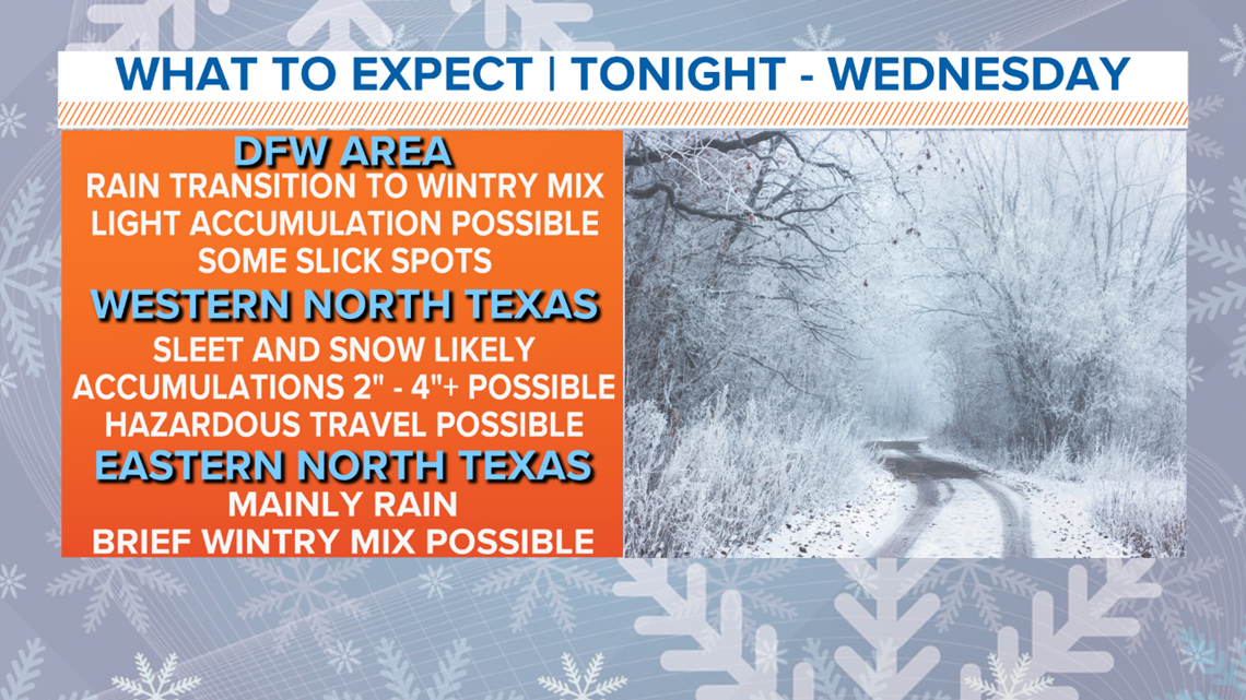
HIGHLIGHTS
A round of wintry weather will begin in North Texas starting late Tuesday night into Wednesday.
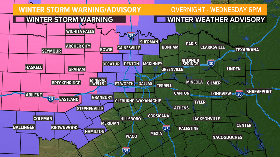
Best chances for sleet and snow, along with the highest accumulations, will be across western and northwestern North Texas. These are the locations where hazardous roads and school cancellations are most likely. A WINTER STORM WARNING has been issued for areas shaded in pink. Areas shaded in purple are under a WINTER WEATHER ADVISORY. A good way to summarize areas that could see slippery travel is as follows: Counties shaded in pink should expect slick roads and hazardous travel Wednesday. Areas shaded in purple have the possibility of a few slick spots mainly on elevated surfaces like bridges and overpasses. Everyone else should still use extra caution, but treacherous travel is not expected.

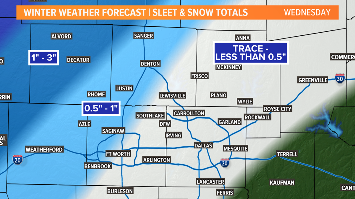
For the metroplex, western sides of the Dallas-Fort Worth area (Denton to Fort Worth to the west) have the best chance at seeing light amounts of sleet or snow, which could cause some slick roads.
For the rest of the Dallas-Fort Worth area, some light amounts or trace amounts of sleet and snow are possible. Widespread, icy roads are not likely for most of the metroplex, but some slick spots are possible.

TIMELINE
TUESDAY
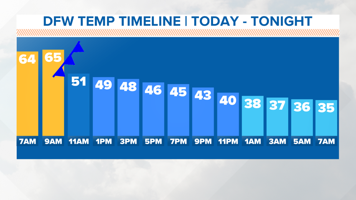
No wintry weather during the day, but much colder temps will return in the afternoon and evening.
A strong cold front will move through North Texas with temps falling into the 40s by midday into the afternoon. The 60s Tuesday morning will not last, so grab the jacket before you head out the door. You will need it!

TUESDAY NIGHT
The night will start off quiet, but cold.
Changes will start to occur during the late night hours into Wednesday morning.
Around midnight, a mix of rain transitioning to sleet and snow will move into western North Texas.
MIDNIGHT TO 7 A.M. WEDNESDAY
Sleet and snow will fall across western North Texas. Accumulations are most likely in these locations with totals of 3 to 6 inches possible.
Through the early morning hours, a wintry mix will creep slowly eastward, reaching the western parts of the Dallas-Fort Worth area by around 5 to 7 a.m.
Some slick spots are possible, with any sleet or snow that sticks mainly across the western part of the Dallas-Fort Worth area during this timeframe.

7 A.M. TO NOON WEDNESDAY
Sleet or snow will continue to fall across western North Texas.
A wintry mix may move a little farther east into the Dallas-Fort Worth area, but best chances for light amounts of sleet or snow will continue to be from Denton to Fort Worth to the west.
The rest of the area could see some trace amounts of sleet or snow, which could lead to some slick spots here or there. Widespread icy roads are not likely, but some slick spots are possible.
NOON TO 6 P.M. WEDNESDAY
Any wintry weather will slowly taper off, with most places not seeing anything falling from the sky by the evening hours.
It will stay cold all day long-- highs will only be in the 30s for most.
WEDNESDAY NIGHT TO THURSDAY MORNING
Cold for everyone. Temps will fall below freezing if they are not already.
Areas that see the highest sleet and snow totals will continue to see slick roads through Thursday morning.
There could be a brief round of lingering sleet or snow mainly across the eastern part of North Texas, but most places will be dry. IF this occurs, it does not look to be enough to cause any problems.
Remember to download the WFAA app to check one of our dozens of local radars near you as well as the latest forecast, cameras and current conditions.