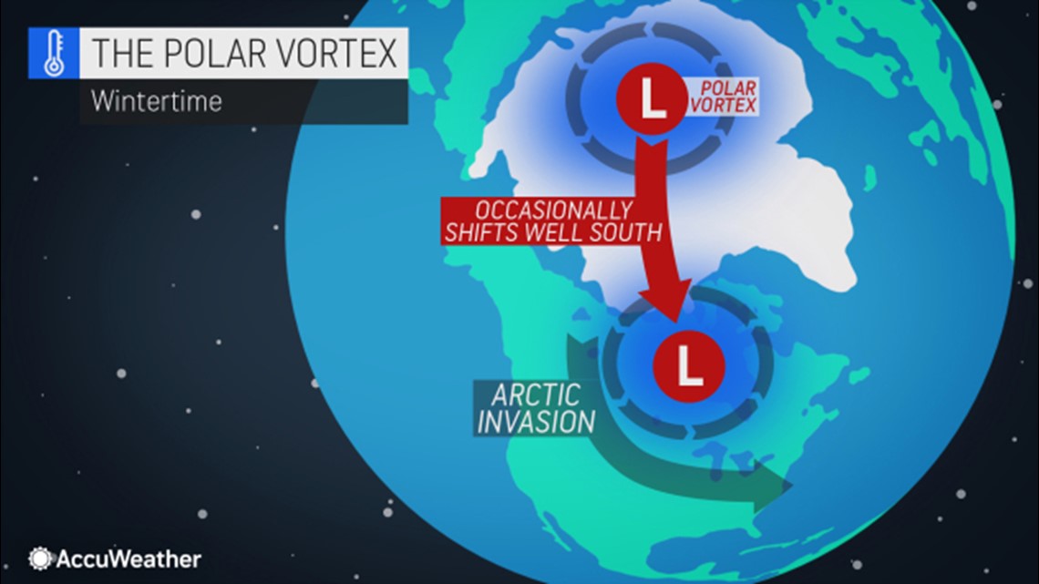
Late in 2020 and early in 2021, AccuWeather meteorologists warned that a weakening of the polar vortex was coming and a major southward discharge of cold air would follow during the second half of January. That big discharge is still coming, but it has been delayed a bit.
When the polar vortex weakens, it can send frigid air southward not only into North America, but also into Europe and Asia.


Determining where exactly Arctic air will settle - and which areas may be missed - is often the biggest challenge that meteorologists face when they see signals that the polar vortex may weaken. It's often not as simple as a big cold blast coming or not, and rather there can be a range of scenarios like smaller, weaker pulses of cold air that plunge south. There are so many variables in the atmosphere that a single phenomenon cannot entirely explain it all.
In this case, early data indicated that the core of the frigid air might take aim from central Canada to the northern Rockies and the northern Plains, according to AccuWeather Lead Long-Range Meteorologist Paul Pastelok.
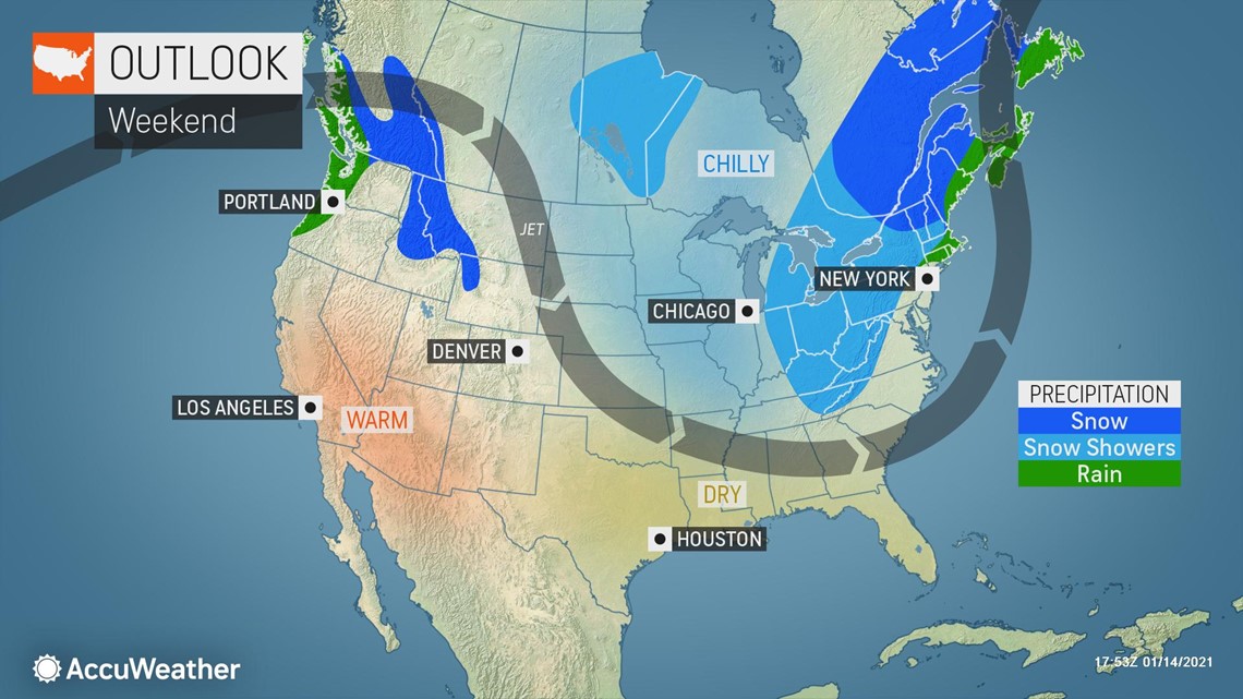
Often storms and buckles in the jet stream that develop ahead of blasts driven by changes in the polar vortex can help determine where some of the coldest air will go -- and when it will arrive. Such will be the case this weekend as a storm associated with a large southward bend in the jet stream will settle from the Midwest to the Northeast.
A wave of cold air originating from Canada will spread from the Upper Midwest to the Northeast this weekend behind the powerful storm that was traveling form the Northwest to the Midwest on Thursday. However, the air will turn milder as it passes over the relatively mild water of the Great Lakes.


"This is the first sign of a change across the northern latitudes following the polar vortex displacement," Pastelok said.
The air mass with the first displacement from the weakening polar vortex will not be all that cold near the surface, and it is following well above-average temperatures that warmed the ground.
"We will see a drop to near-normal or even still slightly above-normal temperatures in the Midwest and Northeast this weekend, then the cold air looks to deepen in the Northeast early next week with temperatures going a few degrees below normal Monday and Tuesday while the Midwest moderates," Pastelok said.
A bigger discharge of cold associated with the polar vortex displacement is still foreseen, but it has been delayed for North America.
Major weather changes developing over the North Pacific Ocean over the next week are expected to allow very cold air to build over northern Canada then send it southward. Thus far this month, temperatures have been well above average across much of Canada, but once Arctic air takes root over Canada, the stage will be set for some of that bitterly cold air to move southward.
"The most persistent frigid air will aim from central and southwestern Canada, the northern Rockies and the interior Northwest from late January to early February with temperature departures of 10-20 degrees below normal," Pastelok stated.


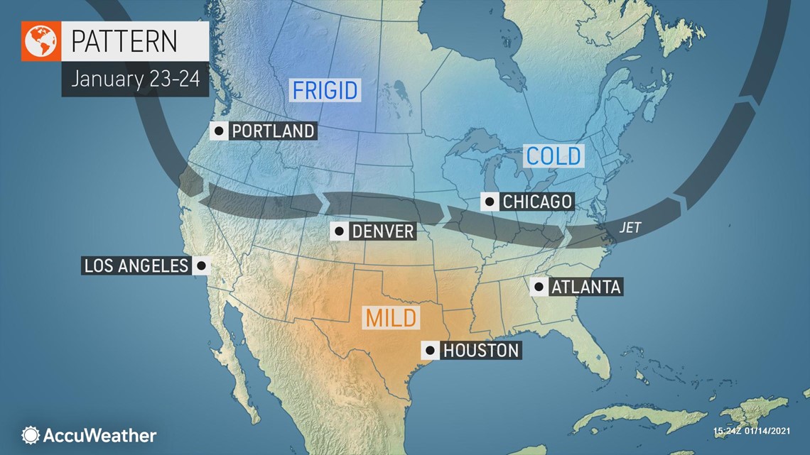
"Much colder air will take some time to reach the eastern third of the nation, but we finally expect Arctic air to arrive during the weekend of Jan. 23-24 with temperatures dropping well below normal across a wide area," Pastelok explained.
The Arctic air will likely come in waves due to storms rolling through with some moderation between reinforcing shots, especially from the Midwest to the East.
A storm that was originally slated for the day before Inauguration Day in the Southeastern states will take shape a day or two later. That storm is likely to be the mechanism to help pull some Arctic air southward from south-central Canada and into more of the central and eastern U.S.
AccuWeather's long-range team expects single-day temperature departures in the northern Plains and Midwest to average 10-20 degrees Fahrenheit below normal and 8-16 degrees below normal across areas farther east during the period from Jan. 24-28.
Temperatures for several days are likely to be 15 to 20 degrees lower than normal from Montana to Alberta, Canada. High temperatures could plummet to near zero, and lows could plunge as low as minus 20 F.
During the first week or two of February, the core of the cold air may remain rooted from the central and northern Rockies to west-central Canada, but temperatures are likely to trend upward farther to the east in the U.S.
"Overall, five-day departures for the last week or so of January 2021 may be 2-4 degrees below normal for the Northeast and Ohio Valley and 4-8 degrees below normal for the Midwest," Pastelok said.
The arrival, or return, of Arctic air does not necessarily mean that cold records will be broken. Not all discharges associated with a displacement of the polar vortex are created equal. To put this upcoming pattern in perspective, the overall discharge of cold air this time will pale in comparison to central and eastern U.S. outbreaks in mid-December 1989, mid-December 1983 and late January 1996.
For example, the six-day outbreak that occurred in Chicago from Jan. 30 to Feb. 4, 1996, was responsible for temperatures averaging nearly 30 degrees below normal. In New York City, the same outbreak from Feb. 1-6, 1996, delivered an average temperature departure of 16 degrees below normal. Meanwhile, in Great Falls, Montana, the same outbreak from Jan. 28 to Feb 2, 1996, produced an average temperature departure of a whopping 42 degrees below normal with high temperatures on a couple of days at or below minus 15 degrees.

