6:40 a.m. UPDATE:
Storms are over Monday morning in North Texas, mostly cloudy skies in high 60s and low 70s. There's another chance of scattered storms with a low severe risk possible this afternoon and evening.
A marginal risk of severe storms in place for the DFW metroplex and the areas west of the area. A few storms this evening could produce some hail and strong winds. The coverage of storms will be lower and the severe risk will be lower than Sunday night.
5:45 a.m. UPDATE: Storms are over Monday morning in North Texas, mostly cloudy skies in high 60s and low 70s. There's another chance of scattered storms with a low severe risk possible this afternoon and evening. The coverage of storms will be lower and the severe risk will be lower than Sunday night. A few storms could gust mainly west of the metroplex.
Remember to download the WFAA app to check one of our dozens of local radars near you as well as the latest forecast, cameras and current conditions.
Check Weather Alerts here.
10:45 p.m. UPDATE:
Storms continue to move south. Can't rule out a strong to severe storm with strong winds over the next several hours in southern North Texas. Severe threat continues to be over for the DFW area.
10 p.m. UPDATE:
Severe threat has ended for the DFW area. However, lingering storms and heavy rain could cause localized flooding, and the lightning threat will continue as well. Severe threat has shifted into southern and eastern North Texas the rest of the night into early Monday morning.
A new Severe Thunderstorm Watch has been issued for southern parts of North Texas until 4 a.m.
RELATED: DFW weather: Lightning strike was cause of radio communications problem at Love Field, DFW, FAA says
9:45 p.m. UPDATE:
Still raining in the DFW area, but the severe threat has mostly shifted south and east of most of the Metroplex. Lingering rain, some heavy, could cause localized flooding in and around the DFW area. Severe storms are still possible for areas south and east of the DFW area over the next several hours. Strong winds of 60mph or higher are possible with any severe storms.
9:20 p.m. UPDATE:
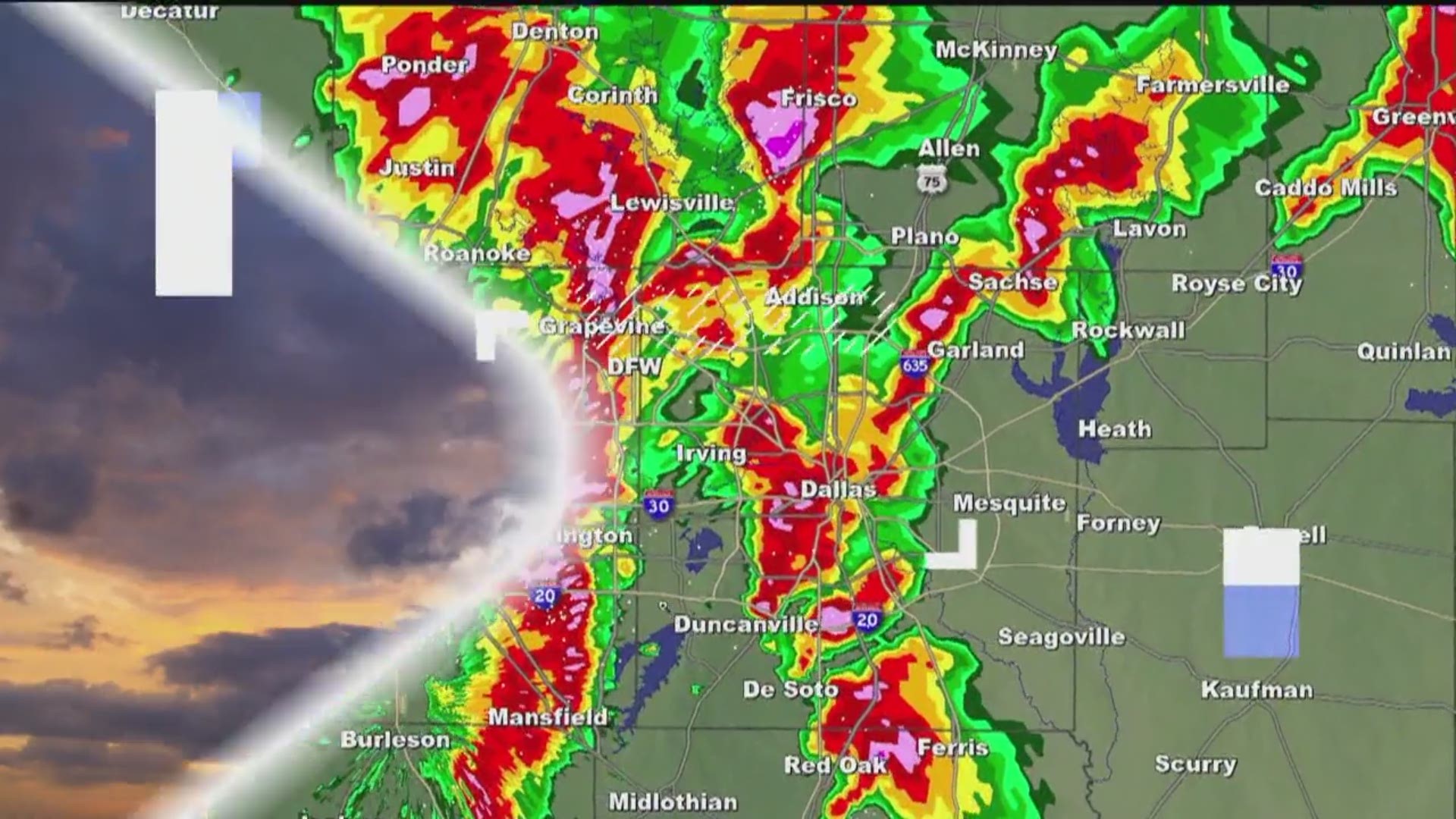
A Severe Thunderstorm Warning has been issued for all of Dallas County including parts of Collin and Denton counties. Damaging winds of 60-70mph are possible as storms move through.
9:10 p.m. UPDATE:
A Severe Thunderstorm Warning has been issued for Tarrant County. Several gusts of over 60 mph have been reported along with one report of a gust up to almost 70mph. Those are strong enough to be damaging. Stay indoors and stay safe!
8:50 p.m. UPDATE:
Storms are moving through the DFW area. Most are not severe at this time, but gusty winds are possible. Heavy rain and lightning are a given.
7:40 p.m. UPDATE:
Any severe storms are across northern and western North Texas at this hour. This is the main round of storms for this evening and tonight. Spotty activity has developed ahead of this line of storms, but will likely not turn severe. Heavy rain and lightning will be the main threats with those.
Main round of storms will likely arrive in the DFW area from north to south between 8:30pm and 10pm. Earlier to the north, later to the south. Some severe storms are still possible with strong winds the main threat.
A Severe T-storm Watch has been posted for much of North Texas including the DFW area until 10:00pm tonight. Though we've seen scattered activity throughout the day, we're not expecting the "main show" until later this evening.
DFW AREA: Timing for storms looks to be anytime after 8 p.m. through midnight. Strong to severe storms will be possible with our main concern being damaging winds. Heavy rain could cause some localized flooding in some places.
Here's a breakdown of the timeline for North Texas:
8PM - MIDNIGHT:
Complex of storms will move south and east through the rest of North Texas. This is also the most likely time frame for most of the DFW area to see storms.
Severe storms will continue to be possible. Since storms will most likely be in a line, damaging winds will be the main threat. Can't rule out some hail or a brief spin-up tornado, but the threat for that is quit low.
Heavy rain and lightning are a given, and any longer-lasting rounds of heavy rain could lead to localized flooding in places.


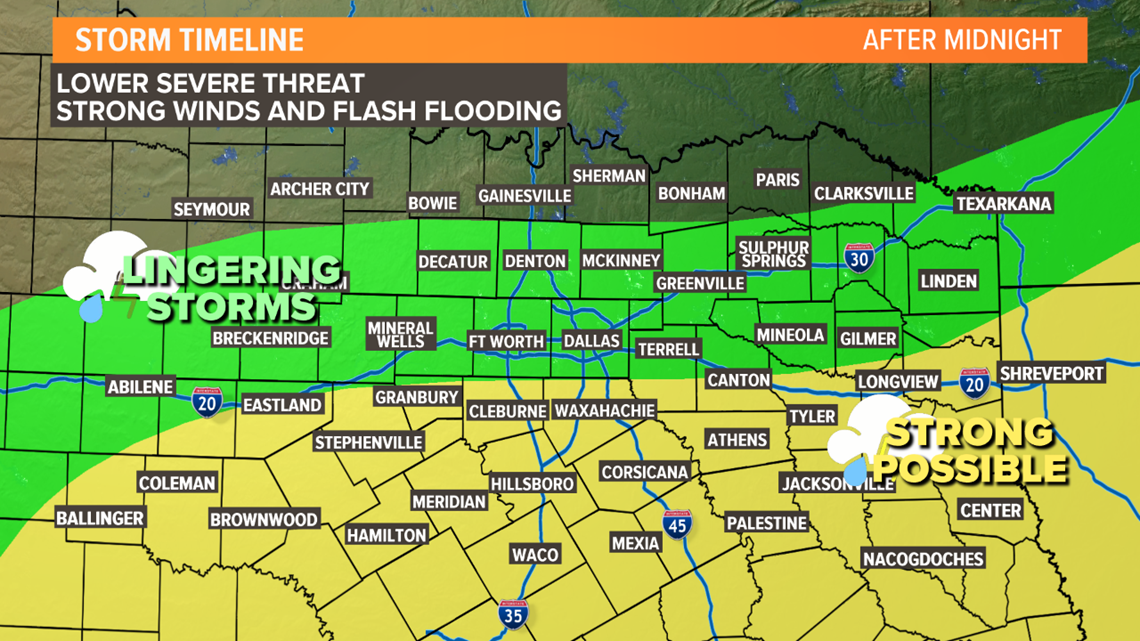
MIDNIGHT - 7AM MONDAY
Storms will move south and east with rain most likely in southern and eastern North Texas. Some lingering storms are possible across the DFW area into central North Texas.
Severe threat will be lower during this time, but still can't rule out some severe storms mainly with a damaging wind threat.
Instances of flooding may be a higher threat during this time as any repeated rounds of heavy rain on top of what fell earlier in the night could cause localized flash flooding.


MONDAY MORNING
Some lingering storms possible to start the day mainly across the southern part of North Texas. Rain and storms will move out with most of Monday being dry after the morning.

